Hamilton County Soil and Water Conservation District
  • Home
  • About
    • About >
      • Staff & Supervisors
    • Donate/Affiliate Membership
    • Jobs & Internships
    • Newsletter >
      • News articles
    • Volunteer Opportunities
    • Strategic Plan
  • Programs & Services
    • Ag Stewardship >
      • Agriculture Resources
    • Drainage
    • Financial Assistance/Cost Share Programs >
      • Invasives Cost Share
      • Landscape Callery Pear Removal Grants
    • Invasive Species >
      • Invasive Trade In Program
      • Landscape Callery Pear Removal Grants
      • Hamilton County Invasives Partnership
    • Map Resources
    • Spring Native Plant Kit Sale
    • Fall Native Sale
    • Rain Barrel Info & Sales
    • Rule 5 Submission
    • Soil Is Alive: Soil Health Trailer
    • Soil Maps & Surveys
    • Soil Testing
    • Stony Creek Feasibility Study
    • Photo Contest
    • Report a Polluter
    • Tool Loan Program
    • Video Resources
    • Water Resources >
      • Well Capping
      • Well Water Testing
  • Urban Conservation
    • Backyard Conservation
    • Landscape with natives
    • Urban Agriculture >
      • Micro-Irrigation
      • Donate Your Vegetables
      • Garden Resources
    • Creating and Maintaining a Prairie
    • Restoring HOA Native Landscapes
    • Stormwater Landscape Maintenance Training
    • Rain Garden Info
    • Seed pack
    • Tree Info
    • Where to buy native plants & seed
  • Events
    • Workshops & Events
    • Rain on Main
    • Pay Dirt Hamilton County
    • Past events & recordings
  • Online Store

Hamilton County SWCD News

LARE Grant Received for Stony Creek

7/24/2019

0 Comments

 
Ginger Davis, Conservation Administrator
​
The Soil and Water Conservation District along with two neighborhoods, James Place and Wellington Northeast in Noblesville have been discussing what could be done with Stony Creek to help reduce erosion and to recreate the flowing stream that once flowed from Greenfield Avenue down to White River. After investigating and talking with experts, it was suggested that the quality urban habitat and stream conditions were well suited to investigate the issue further.   With the awarded $40,000 grant through the Lake and River Enhancement, an engineering feasibility study will help determine the best course of action to address the stream bank issues, downcutting issues, and the influence from low head dams in the area.  The goal of the Department of Natural Resources, Division of Fish & Wildlife's Lake and River Enhancement (LARE) Program is to protect and enhance aquatic habitat for fish and wildlife, and to ensure the continued viability of Indiana's publicly accessible lakes and streams for multiple uses, including recreational opportunities.

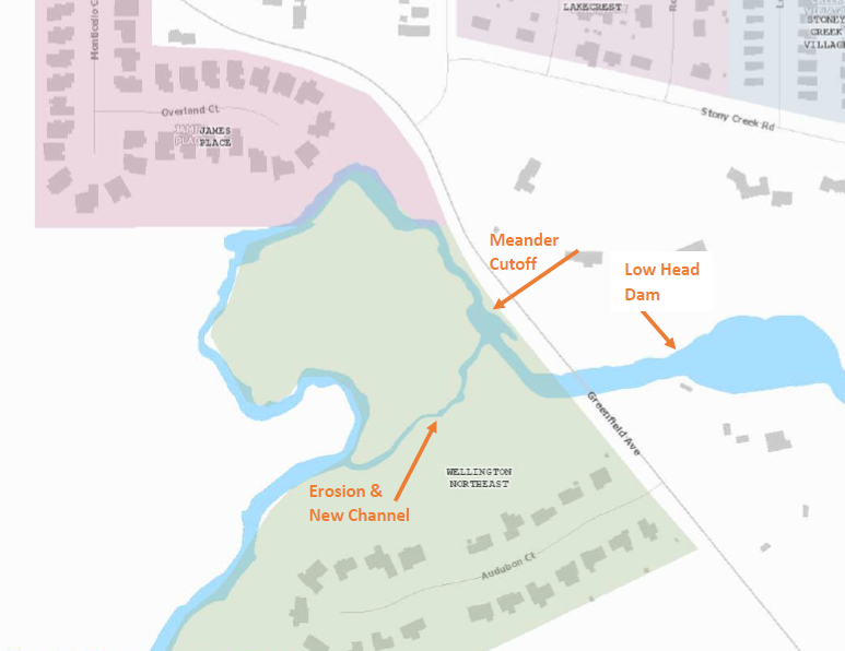
The stream, which once flowed along a 1,900-foot bend in the stream along the edge of James Place, now takes a 500-foot shortcut through the land of the Welling ton Northeast homeowners.  That is a loss of 1,400 feet of stream habitat, along with several tons of sediment that is making its way down Stony Creek and the White River. As a result, the homeowners have seen a loss of land and increase in long lasting flooding conditions in their backyards.  Additional speed (rate of flow) of Stony creek is likely due to the increase slope in the short-cut making bank erosion more serious as Stony Creek makes its way to the White River. The grant is necessary due to the complexity of the project and the potential for loss to infrastructure in this area. 

Picture
The original Stony Creek channel was blocked during a utility crossing and has progressively been further blocked over the years causing an unnatural meander cut-off to occur. Erosion of the side channel due to this alignment causes significant erosion with  continual loss of trees and other sources of bank stability. The original channel area has been used as a utility crossing, which may have been the source of blockage. This crossing has been utilized for many years and local accounts mention that the area has been filled with stone by utility workers. We believe that the excess stone from utilities crossing, along with the construction of the under-stream sewage line, stream realignment in between the late 1980’s and early 1990’s under Greenfield Ave during road reconstruction, and construction of a low head dam in the 1960’s, all have contributed to the issue at hand.
  
The channel diversion has cut through to an area that previously had a minor drainage feature. Visual evidence has suggested that this channel is experiencing downcutting and bank loss at an extremely fast rate. Aerial imagery shows that in one particular location since 2009, approximately 1,400 square feet of bank has been lost.  This channel, once only 5.6 ft wide is now averaging 28 ft. Along the new short-cut,  an estimated 8,750 square feet of land area has been impacted by erosion and carried to the White River.

The original channel has a legal drain that enters into it from the north which historically was a location of the Bridgestone Clean-up site. PCB levels in Fish Tissue have retreated below detection level in this area along with well samples and other measurements taken from this area showing that the PCBs are not an issue. Restoring this area to a recreational asset would be of benefit to the community as a result of this.
​
A low head dam constructed in the late 1950's and rerouting of the stream in the late 80s early 90s may also have been catalysts to this adjustment. These stresses on the system, caused the stream to actively cut off a meander, which has caused significant bank erosion and head cutting of the stream. We believe that if left unaddressed this channel head cutting will proceed under the bridge of Greenwood Avenue. This would compromise the structural integrity of the bridge-- making it a potential hazard for the community. The head cutting may continue adjusting upstream to the low head dam. There would be the potential for the low head dam to become more dangerous to recreational users with an enlarged plunge pool. The high-quality steam upstream of the dam has been restored for wetland function and would be a great location for aquatic species to retreat to during flooding events from the White River.

However, the low head dam makes it impossible for fish and other aquatic wildlife to move upstream to calmer waters during a flooding event. The low head dam in this area blocks sediment and therefore has been filling in the recreational pond with sediment making it much more like a stream in recent years.
​

The LARE funded engineering feasibility study will be conducted by a third party to determine the best method to address the situation in this area to make it much more stable and allow for increased habitat in this urban center.
0 Comments

Your comment will be posted after it is approved.


Leave a Reply.

    Author

    Write something about yourself. No need to be fancy, just an overview.

    Archives

    May 2025
    April 2025
    March 2025
    February 2025
    December 2024
    November 2024
    October 2024
    August 2024
    July 2024
    June 2024
    May 2024
    March 2024
    January 2024
    December 2023
    August 2023
    June 2023
    March 2023
    August 2022
    July 2022
    June 2022
    May 2022
    March 2022
    January 2022
    November 2021
    October 2021
    August 2021
    July 2021
    March 2021
    January 2021
    December 2020
    October 2020
    June 2020
    April 2020
    March 2020
    January 2020
    October 2019
    September 2019
    August 2019
    July 2019

    Categories

    All
    Canada Thistle
    Crop Diversity
    Garden Tower
    Hamilton SWCD
    Indiana
    Invasive Species
    Karner Blue
    Lupinus Perennis
    Native Plants
    Pet Safety
    Soil Health
    Soil Testing
    Urban Conservation
    Urban Gardening
    Volunteer
    Water Quality
    White River
    Wild Lupine

    RSS Feed

Your SWCD

​About
​Services
Newsletter
Volunteer
Contact Us

[email protected]
317.773.2181
1717 Pleasant St. Suite 100
Noblesville, IN 46060
Established in 1968
© COPYRIGHT 2022. ALL RIGHTS RESERVED.
Photo from andurache